Currently reading: Jeff Greenwald – Shopping for Buddhas (still) | Oliver Sacks – The River of Consciousness | David Foster Wallace – Infinite Jest
The quest for the Abels has begun! I have thus far only been to the top of a small handful: Roland (1234m), Rufus (1416m), Legges Tor (1572m – and I’m not sure I can count this as Mum and I drove as far as you can in a car to get to the summit of Ben Lomond, Tassie’s second highest peak), and now, Mt Arthur (1188m).
Despite having walked the Overland in each direction (St Clair to Cradle in 2002 and Cradle to Clair in 2006), I have yet to make it up Ossa, Tasmania’s highest peak. In ’02 I was hiking solo with minimal gear and was advised not to attempt the summit without snow shoes. My friend Laura and I did try for the summit on our ’06 hike, but we didn’t have the gear to traverse the snow at the pass safely, so we turned back. Admittedly, both hikes were completed in October, when snow can be expected, so next time I hike the Overland track I think I’ll choose a warmer and drier month.
The Abels are a list of Tasmania’s 158 highest peaks. You can read all about the Abels at the Abel Mountains Website, which functions as a companion piece to the 2 volume book set edited by Bill Wilkinson on the subject. Wilkinson observed the following criteria when compiling the Abel Tables:
-
choosing a minimum height of 1100m. This provides a reasonable altitude range of 517m, i.e. 1617m (Mt Ossa) to 1100m. Peaks lower than a third the height of Mt Ossa are not considered to be mountains on a state-wide basis.
-
defining a mountain in this height range as having a minimum drop of 150m on all sides before higher ground is reached, regardless of extent. This allows the highest peaks in plateaux and ranges to be selected and relegates other peaks as subsidiary hills.
For a detailed discussion of hikers who have completed the Abels thus far (and for all things related to hiking in Tasmania and beyond), see Louise Fairfax’s List of Top Abelists at her excellent blog Nature Lovers Walks.
Mt Arthur had been on my mind for some time. My Grandmother used to say “Arthur pushed a Barrow up Ben Lomond” as a way of identifying the three peaks you can see from most places in Launceston, and while spending time with my folks earlier this year, I expressed an interest in climbing them. Mum and I drove and rock scrambled up Ben Lomond in April, and when I got off the plane this visit, I suggested we climb Mt Arthur, so on our last day in Tas, Steve (my bro), Sam and Ollie (my nephews) and I set out in search of the summit with Naida (Mum), John (1st cousin once removed) and Frank (his dog).

The Jillett / Chaplin clan
I’d found a good write up about it on the Hiking South East Tasmania blog, which aided us with finding the right road to the trail-head (Mountain Rd off Lilydale Rd), though we had some trouble locating the start of the track itself. We’d followed the advice on the blog post to walk approx 230 metres along the road to the start of the trail from where we parked, but there were two options here and neither yielded results. We were on the verge of giving up when my brother, after a little bush bashing, managed to locate the track. When we returned to the cars at the end of our walk, we saw that the trail-head was clearly marked (complete with sign and high vis ribbons) right beside our cars. We’re not sure whether we parked in a different spot to where Denis (the author of Hiking South East Tas) had parked, or whether the trailhead has been relocated slightly since his 2014 posting, but we got there in the end.
To future hikers wanting to summit Mt Arthur, drive as far as you can along Mountain Rd until you hit the private property line, then look for the sign to the trail in immediate proximity to your vehicle.
My brother mapped our walk with his garmin.
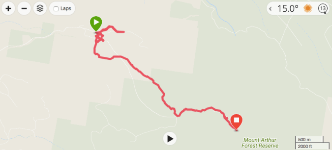
That squiggle at the start shows our bewilderment with trying to find the trail…

Detail of our initial meanderings. We walked in circles for about 2 and half km before we started the walk proper – heh heh
Once on the trail, though, it was clearly marked all the way to the summit cairn:

Jillett juniors with Frank

Jillett juniors left to right: Sam, Ollie and Steve

Steve looking all nonchalent

Love these lichen covered Tassie forests

The scramble begins

Checking stats (and the view)

Crossing the summit ridge

Ascending to the cairn – the best quote of the holiday goes to Ollie, who, the day before the hike asked Mum how old she was and upon hearing the response, stated: “You’re in good nick for 71 Grandma!”

Summit cairn in sight

Sam, at 6’7″, steps nimbly from rock to rock while Mum and I follow with various combinations of roll, crawl, heave and scramble

We made it! We lunched at the base of the summit cairn, out of the wind

Beautiful moss and lichen in all manner of shades, colours and textures

The wild and rocky ridgeline

Pano to the northeast

Radio towers, solar panels, wind turbines and all kinds of other infrastructure can be seen dotted along the ridge

Descending to treeline once more

My boots have seen better days

I picked up some gimmicky attachments for my phone-camera over the chrissy period (all my photos are taken with my phone at this stage – post thesis I’ll buy myself a you-beaut Canon and get serious about my photography) – it turns out the macro lens does a pretty decent job for a cheap add-on accessory… This spider was about half the size of my little fingernail

Back in the forest surrounded by lush moss and an abundance of ferns

Elves dwell here

Note the suggestion to ‘rest’ carved on the wooden log at the bottom left of shot

An entire micro-universe is thriving in this rotting tree stump
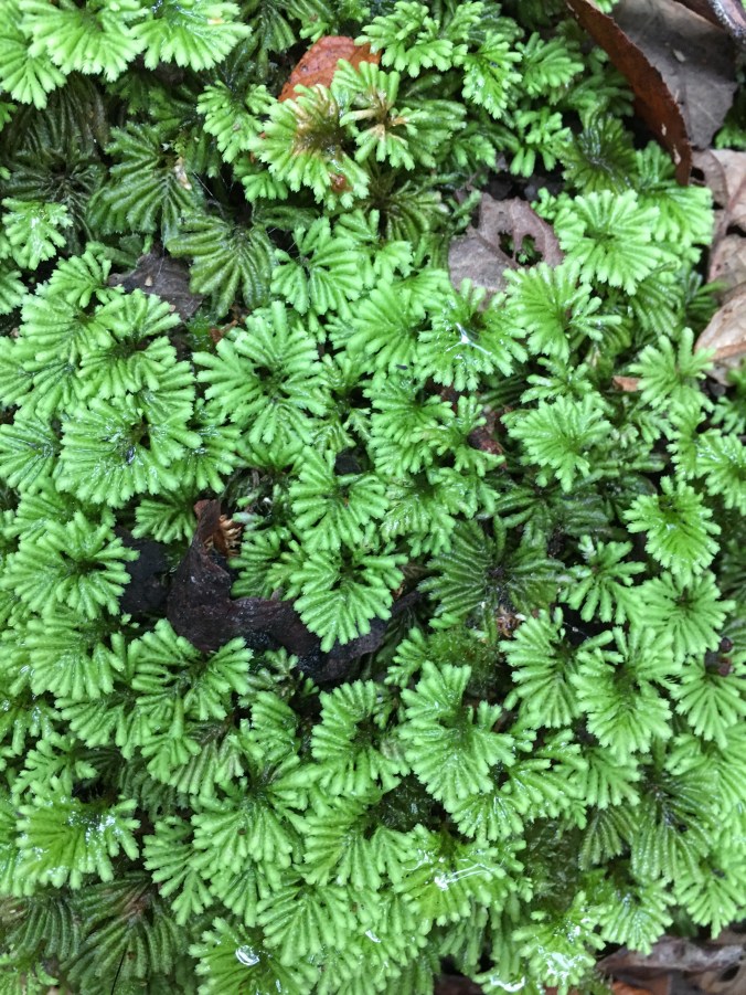
I think I have identified this as Hypopterygium – this teeny tiny moss was growing all over the rocks and trees of the forest floor
All in all, despite our early trouble with finding the trail, this was a fantastic walk, and suitable for all ages. Our party ranged from 14 to 71 years (plus dog). It took us 5 hours, including a lunch break at the base of the summit cairn and a couple of short snack breaks where the treeline meets rocky scree.
Books Completed: Levison Wood – Walking the Himalayas | Cristina Garcia – The Lady Matador’s Hotel | David Mitchell – Black Swan Green

It was a great walk, thank you Lou for suggesting it and getting us motivated to do it.
LikeLike
Thanks Steve! It was a good workout wasn’t it? And amazing views. We should do Frenchmans Cap next time we’re all in Tas 👍😁
LikeLike